
A Singaporean traveller shares a travelogue of his journey from Lanzhou to Dunhuang, offering a taste of what explorers can look forward to on the Asian Geographic Silk Road China Expedition in 2017
Text Robert Yeo
Photos Michael Lee
The City of Waterwheels
Our eight-day journey started in Lanzhou – the capital and largest city of Gansu Province. Lanzhou linked the ancient capital Xi’an with Central Asia and the Roman Empire via the famed Silk Road.
The Yellow River forms a labyrinth in the city, compartmentalising it into different districts. The river is so named because of its jaundiced colour. The channels of water in this old city are home to many waterwheels – invented by Duan Xu during the Ming Dynasty (1368–1644) – which were once used for extensive irrigation, transporting the river water into the neighbouring farmlands.
But where once there were over 250 waterwheels along this river, earning Lanzhou the nickname “City of Waterwheels”, today the modern Waterwheel Garden, built in 1994, serves as one of the few reminders of this rich history.
One of the most interesting activities in Lanzhou is the tradition of raft making – from sheepskin. These rafts are still used to ferry goods and people, and daring visitors can make the journey across the river in the rudimentary vessels. However, the strong current necessitates that trips can only be made one way.
After overnighting in Lanzhou, we made our way to Qinghai Lake, stopping at the Kumbum, or Ta’er, Monastery, about 27 kilometres outside of Xining. The huge monastery is still home to 400 monks of the Gelugpa sect, and is one of the two most important Tibetan Buddhist monasteries in existence.
Built in 1577, the history behind the monastery began with the birth of the famous Buddhist teacher, Tsongkhapa, the founder of the Gelugpa sect. His mother built a small temple at the site of his birthplace, which today stands as the Grand Hall of Golden Tiles (댕쏜崑등; Dàjīnw Diàn), featuring an 11 metre-high stupa, or chorten. The original temple grew to become the impressive monastery that it is today, consisting of nine temples, each with its own distinctive features. The yak butter sculptures (更答뺌반; Sῡyóuhuà Gun) are particularly impressive.
We headed to Qinghai Lake, arriving in the early evening. As the sun sets quite late in Gansu Province – at around 8pm, when we were there – we had quite a wait for the sun to go down. As the weather was overcast, there was no chance of any spectacular sunset photos, but the panoramic view of Qinghai Lake was still a sight to behold. It was blissfully cool, owing to the high altitude – 2,800 metres above sea level. A moon rose, banishing the mediocre sunset from memory.
Mirroring the Sky
Early the next morning, we began our journey west to the Chaka Salt Lake, passing by vast grass fields leading up to the foot of the magnificent Qilian Mountains. “Chaka” actually means “salt lake” in Tibetan, rendering the English name redundant.
The lake covers an area of 105 square kilometres, with enough saline to meet the world’s salt needs for more than 160 years. It forms a perfect mirror, so much so that it’s difficult to tell where the landscape ends and the sky begins.


With bare, salt-crusted feet, we clambered back into the vehicle to make our way to the majestic Qilian Mountains in the winding journey to Dunhuang, breaking the trip up with an overnight rest.
Arriving in Dunhuang – a location of strategic importance, at the juncture of two major trade routes within the Silk Road network – our first stop was the Dunhuang Yardang National Geopark, an eerie landscape of geological landforms dispersed across the arid desert. At 38°C, it was the hottest day of the year when we visited, but a gentle wind – the same force responsible for the gradual erosion of rock into the remarkable geological structures – swept through the park, and provided a welcome relief from the oppressive heat.
We then ventured to the Yumen Pass, also known as the Jade Gate. This gateway once provided passage for travellers along the Silk Road, connecting Central Asia and China.
A Labyrinth of history
The Mogao Caves (칭멕욀) – also sometimes referred to as the Caves of the Thousand Buddhas (푤뤘떪) – consist of a network of 492 temples, with some 2,100 coloured statues and 45,000 square metres of murals.


The “library cave” houses 40,000 scrolls that have provided historians with a richer understanding of the Silk Road. UNESCO reports that the first caves were founded in 366 AD by Buddhist monks, establishing Dunhuang as an epicentre for Buddhist learning, attracting many pilgrims to the city via the Silk Road. Photography is not allowed so as to preserve the caves, which house artworks contributed by the Turks, ancient Tibetans and other Chinese ethnic minorities. Sadly, some of the murals and scriptures originally found were illegally excavated and transported to museums abroad.
The Singing Sand
We then visited the Echoing Sand Mountain, a series of the Gobi Desert’s sand dunes that tower around Crescent Lake. The name of the former is derived from the echoes that can be heard as the wind whistles across the dunes, often called the “singing sand” phenomenon; the latter’s name is derived from the shape of the oasis.
The Chinese government has developed tourism in this area, and plenty of activities are on offer, including camel rides, paragliding and buggy rides. We clambered up the sand dunes to get to a better vantage point from which to watch the sunset drench the basin in shades of orange.
Following an early start and a detour via the White Horse Pagoda, we made our way to Xuan Bi Chang Cheng (技귿낀냘), translating to “Overhanging Great Wall”, which was thought to have been built during the Ming Dynasty between 1539 and 1540 by commander Li Han in order to strengthen the Jiayu Pass defence. It formed the entry pass at the western end of the Great Wall of China.
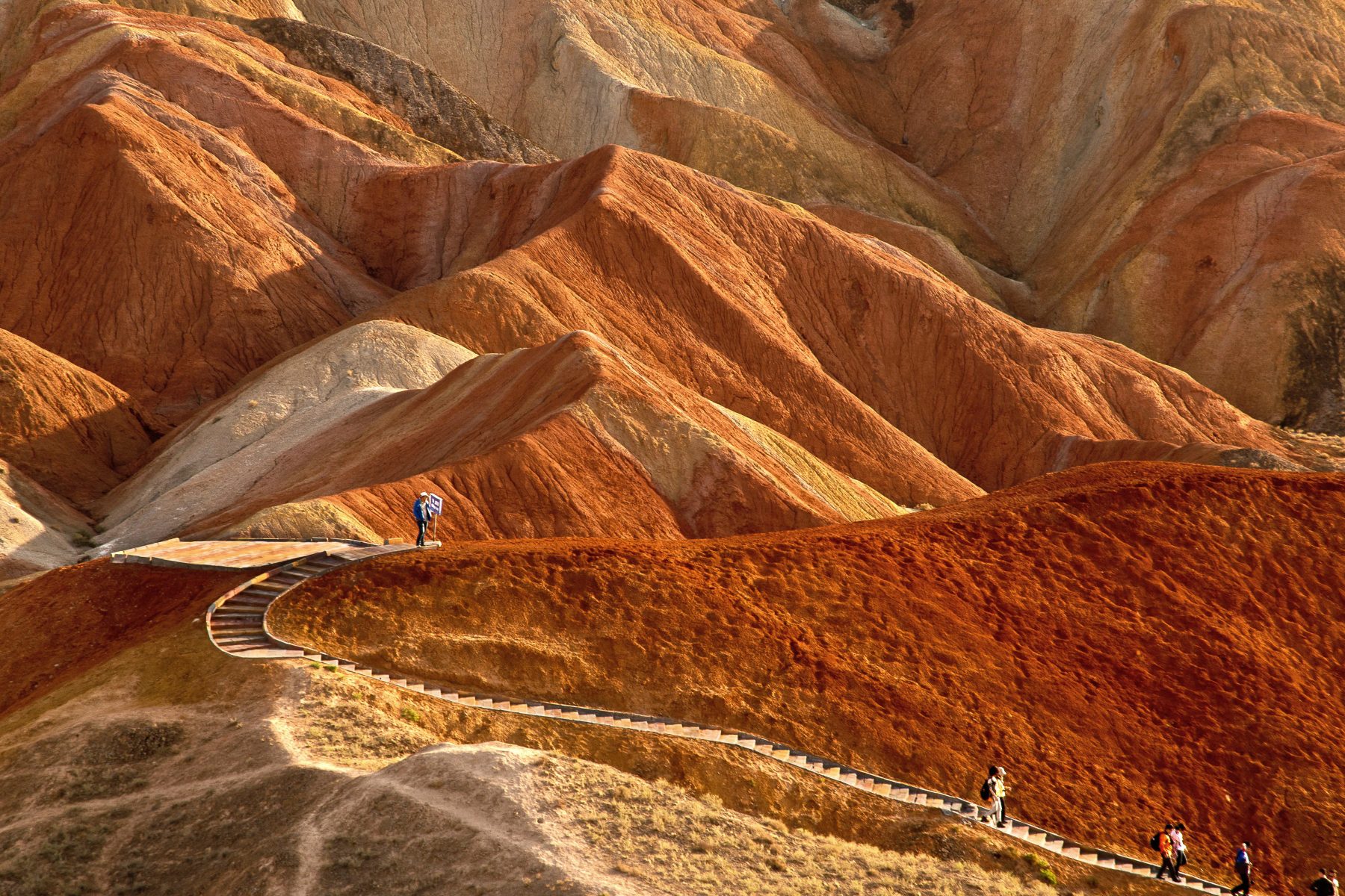
The Rainbow Range
The next morning, we arrived at the first pier of the Great Wall. Built along the cliffs surrounding the Beida River, this area once played host to several military camps. By the afternoon, we were headed east towards the Zhangye Danxia Landform Geological Park. The landforms here resemble a multicoloured layer cake, consisting of strata of different coloured sandstone and minerals, forged over the course of 24 million years.
Marked as a UNESCO World Heritage Site since 2010, it is thought that at one time, the area was completely submerged underwater. Over the years, the landscape emerged, shaped by the movement of tectonic plates and the onslaught of wind and rain, carving out the cliffs and ravines that we find today. This was a highlight of the trip – and a good note to end on.


We began the journey home, driving the long road back to Lanzhou from Zhangye, passing by mysterious Tibetan mani stones and golden rapeseed plantations – some of the largest in the world – before arriving in Lanzhou for our respective flights out.
Having been to the first pass of the Great Wall in the west, I hope to make the journey to the first pass of the Great Wall in the east. Personally, this trip was one of the best I’ve experienced in my lifetime. It was an eye-opening journey that allowed me to learn more about Chinese art, heritage and culture, and the fascinating history of the Silk Road.
For more stories and photographs from this issue, see Asian Geographic Issue 124, 2017


