Text by YD Bar-Ness
There are some places on the map that no person can visit, and yet, they are charted with precision and confidence. Java La Grande, Locach, Magellanica, Terra Australis Incognita, the Region of Parrots, Ophir, Australia del Espiritu Santo – these are places mapped onto the mythical Southern Continent, in spite of the fact that they never existed. The continent itself was a myth and a dream that, nevertheless, amazingly, turned out to be true.
A reflection in the mirror shows us order and symmetry in the natural world. We see things in harmonious balance, and there is a sensibility to our disordered world. If you believe in the powers of reason and rationality, that there is order and balance to the world, you would naturally reason that the entire landmass of Asia is counterbalanced by an equally vast continent in the Southern Hemisphere. This is apparent, and sensible, because certainly an unbalanced globe would topple out of control as it orbits the Sun… would it not?
Unfortunately, reason is sometimes wrong and it turns out that there is no colossal continent of the south. The Southern Hemisphere is mostly ocean, and lying lonely at the bottom of the world, Antarctica is icebound and storm swept.
Rumours of a Southern Land
The first Americans and the first Australians were obviously well aware of their surroundings as they travelled southwards on the landscape. Humans are thought to have reached Australia at least 40 millennia ago, and the southernmost isle of Tasmania at least 20 millennia ago. In the Americas, humans are thought to have reached the southernmost island of Tierra del Fuego about 8,000 years ago. While they may not have left us a strong record of mapmaking, our story of the mythical Southern Continent is one specific to the Eurasian civilisation.
From the perspective of the Christian, Islamic and Chinese empires of the last 2,000 years, deeply held notions of world order were shaken as communication links grew. Travel and trade forced these communities to accept that they were not, in fact, occupying the centre of the world.
As they did in so many other things, European mapmakers followed on from Aristotle’s ancient writings: the Arktos, or the northern lands, were undoubtedly counterbalanced by the Anti-Arktos. Greco-Roman astronomer and geographer Ptolemy, assembling
a coordinate map of the known world, also wrote of a Southern Continent linking India and Africa, but declared it was beyond a hot and dry desert, and inhabited by monsters. He labelled it the Unknown Southern Land – later latinised as “Terra Australis Incognita”.
In the Biblical stories of Solomon, which are held sacred by Muslims, Christians and Jews, there are records of tributary offerings of gold arriving from the southern kingdoms of Ophir and Tarshish, but there is little other information to connect these with any other known lands.
In the Hindu world, a magical southern land existed relatively close to home and was the venue for much of the action in the epic Ramayana (dated variously from 500 BC to 100 BC). Known as Lanka, it is now clearly identifiable on a map, but the demons and landscapes from the story live on in the realm of mythology. By the year 75 AD, Buddhist and Hindu seafarers would travel east in the Indian Ocean to Java and establish solid trade links, but it is unknown if they explored southwards.
In the centuries to follow, the Islamic mercantile world would lead the way in mathematics and mapmaking.
On the eastern seaboard of Asia, in China, whatever the popular conceptions of the existence of a great southern land, it remained unrecorded on a precisely drafted map until the year 1602, when an Italian missionary named Matteo Ricci worked with the Wanli Emperor to create a world map: Kunyu Wanguo Quantu, “The Map of the World’s Myriad Countries” (坤輿萬國全圖).
In this fusion of geographical knowledge, a southern continent was clearly shown, occupying as much of the Earth’s surface as the known continents of Eurasia, Africa and the Americas combined. Earlier East Asian maps, such as the 1389 Chinese Da Ming Hun Yi Tu, “Combined Diagram of the Ming Dynasty” (大明混一圖) or the 1402 Korean Kangnido, “Map of Integrated Lands” (강리도) stretched outwards to central and southern Eurasia, but never farther south than present-day Indonesia.
We can imagine the sensations that this Chinese emperor must have had at viewing this important map. While China was in the centre of the map, it was the first map he would have seen that demonstrated the existence of a competing civilisation in the far west. It placed the Empire of China in its proper scale relative to the continents, showed the unknown lands of the Americas, and furthermore, a marvellous region of blank, unknown land drew the imagination south.
How did such a misconception grow to occupy almost half of the planet? How did such an optimistic and erroneous idea travel clear across the Eurasian landmass?
Charting a Geographical Myth
The scholars of the medieval period had, of course, a limited understanding of the world’s geography. Cosmas Indicopleustes, or Cosmas the Indian Traveller, was
a sixth-century Christian merchant who travelled from the Mediterranean to India. He mocked the idea that people could live “upside down” in the southern part of the world – and indeed, the whole idea that the Earth was spherical.
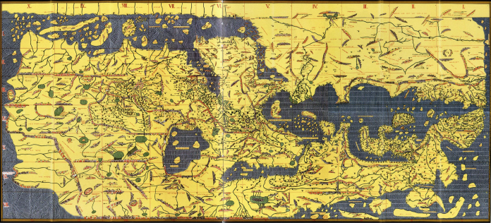
In the centuries to follow, the Islamic mercantile world would lead the way in mathematics and mapmaking. In 1154, King Roger of Sicily served as patron to the talented Moroccan geographer Muhammad al-Idrisi. With the ambitious goal of charting the entire world, this was the first major cartographic effort combining the Christian and Muslim maps of the world. They carefully inscribed their map onto a giant silver plate, centred on the Mediterranean and extending towards a vastly simplified Eastern Asia. The northern part of Africa was charted well, but the Sahara desert connected with a landmass encircling the world at the equator: this impossibly hot region veiled the unexplored lands of the south. Al-Idrisi wrote that it was impossible to sail south of Zanzibar along the African coast, indicating the distinct limits to the Islamic world’s knowledge of the south.
Marco Polo, in his celebrated travels overland from Venice to the Chinese court of Kublai Kahn in the late 1200s, returned to Europe with many tantalising tales. Besides
his descriptions of the sumptuous riches of the East, he sparked the imaginations of Europeans with his glowing descriptions of the islands we now call Indonesia, including that of Java Minor, which is what we now call Sumatra. He describes, second- hand, the nearby isle of Java Major, the largest island in the world, and how beyond these were two fabulously wealthy islands. To Europeans, paying tribute to Solomon, these were readily identified as Ophir and Tarshish.
These errors and hopes became crystallised into the historical record as printed maps became more abundant. By the early 1500s, cartographers were experimenting with flat depictions of a spherical planet and the American continents had been placed on the world maps. These continents on the far side from Europe lent a certain symmetry to world maps and it was a reasonable thought to imagine that just as the Americas balanced the Old World, so too would Terra Australis. Portuguese explorer Ferdinand Magellan’s fleet sailed from Spain to successfully circumnavigate the globe, crossing the Atlantic and passing through the Straits of Magellan between the island of Tierra del Fuego and the southern tip of South America, and across the Pacific to the Philippines. Magellan believed that Tierra del Fuego, to the south, was part of a greater mainland. For centuries after their voyage, mapmakers labelled this continent Magellanica.
Two other Spanish expeditions explored the Pacific and imagined they had reached the Southern Continent. Álvaro de Mendaña left Peru in 1567 and arrived in the Polynesian islands believing he had found Tarshish and Ophir; he named these the Solomon Islands. Later, in 1606, Ferdindes de Quirós returned to the Pacific and arrived in the tropical island of Vanuatu. Utterly convinced he had reached the Southern Continent, he named this land Terra Australis del Espiritu Santo, or the “Southern Land of the Holy Spirit”. Future maps tried to integrate his discoveries, labelling imprecisely defined southern lands as “Terra de Quirós”.
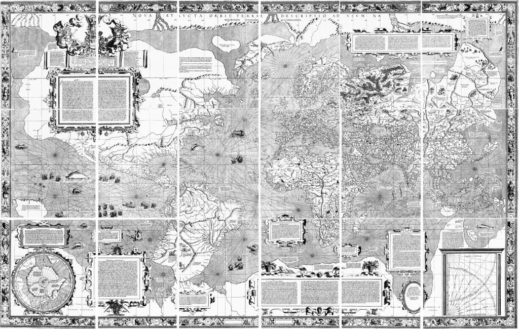
The most influential maps showing the Southern Continent were those of the cartographers Gerardus Mercator and Abraham Ortelius, who were contemporaries and friends in late 1500s’ Belgium. Mercator calculated the two-dimensional map projection of a spherical globe that is used overwhelmingly today and published it in a world map designed for practical navigation. A detailed depiction of a Great Southern Continent is included, coming close to the tip of South America at the Straits of Magellan and labelled as Tierra del Fuego. He adds a Latin inscription for the Southern Continent: “It is certain that there is a land here, but its size and the limits of its boundaries are uncertain”.
Using similar source material, Ortelius published the first standardised world atlas, the Theatrum Orbis Terrarum, or “Theatre of the World”. In this important and expensive publication, he includes place names on the Southern Continent (near what is actually Northern Australia): “Locach” and “Beach”. Both of these names originally come from Marco Polo’s mention of a place near Vietnam called “Locac”, but misprinted and mistranslated by later mapmakers until it was thought of as two distinct places on the unexplored Southern Continent. Inexplicably, another region is labelled, “Psittacorum Regio”, or Kingdom of the Parrots. This was perhaps a result of confusion with the parrots of the more well-known Brazilian rainforest.
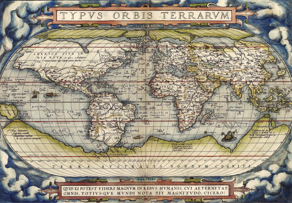
The works of Ortelius and Mercator were the basis for many future maps and voyages, including the cosmographic maps of Dutch-German cartographer Andreas Cellarius and the circumnavigation of the world by English navigator Sir Francis Drake. It was also the basis for the Kunyu Wanguo Quantu, Ricci’s map printed in China.
The Italian missionary, however, did not tell the whole truth to the Chinese Emperor – he spoke falsely of a Europe uniformly faithful to the Pope and created a more interesting map
by appealing to the court’s interest in exotica. He filled in the lands of Earth with a combination of Ortelius’s decorations, including Brazilian subterranean cannibals and Malaysian flying dragons and with legendary Chinese locations, such as the Kingdom of the Ox-hoofed People, the Land of Dogs, and the Land of Night Spirits.
Of Indian and Muslim civilisation, there was little mention: his goal was to simultaneously impress the Chinese Emperor with the achievements of Europe and the Catholic Church and to flatter with the central depiction of the Chinese world.
Read the rest of this article in Asian Geographic Passport No.103 Issue 2/2014 by downloading a digital copy here!


